
What Happens If a Drone Loses GPS Signal?
Bywpdev
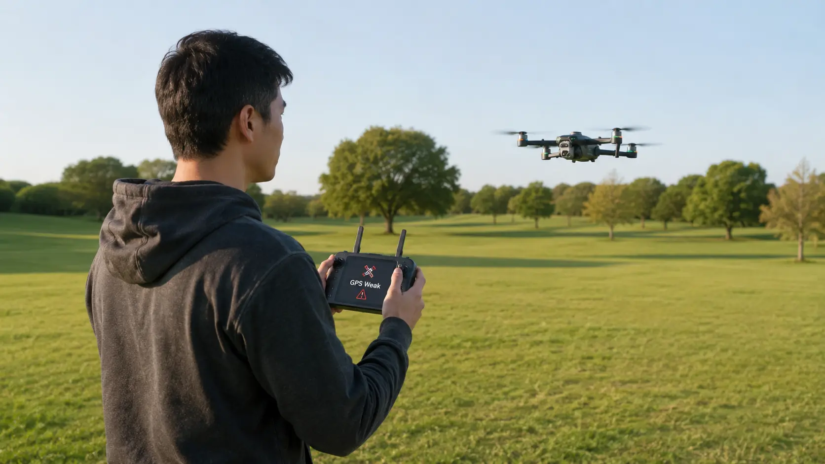
What happens if a drone loses GPS signal? On many consumer GPS drones, losing satellite positioning does not automatically mean losing radio control. The aircraft may stop holding its horizontal position as confidently, begin drifting with wind, fall back to another supported positioning mode, or limit GPS-dependent functions such as return-to-home. Exact behavior varies by model and firmware.
- Stop extending the route. Keep the drone close enough to understand its movement.
- Confirm you still have control. GPS loss, controller-link loss, and video loss are different failures.
- Use small stick inputs. A drone without normal GPS position hold may require continuous manual correction.
- Do not depend on RTH. GPS-based return functions may be limited or unavailable without valid position data.
- Recover toward a clear, known landing area. Move toward open sky only when that path is already safe.
- Land if stable positioning does not return. Do not turn a positioning fault into a battery, distance, or obstacle problem.
A GPS warning can feel like a flyaway is about to start, especially for a beginner who bought a GPS drone precisely because it hovers in place. The important distinction is that GPS is one part of the flight-control system. The remote-control link, video link, motors, inertial sensors, downward positioning sensors, and GPS receiver are separate pieces. One can degrade while the others continue working.
Do not press every button, force an automatic return, climb blindly, or fly farther in search of satellites. First confirm what still works normally, then reduce the flight to a simple recovery: maintain control, keep the route clear, and land in a safe area.
What Happens If a Drone Loses GPS Signal in Flight?
The first change is usually not a motor shutdown. GPS primarily gives a compatible drone position information. If that position source becomes weak or invalid, the flight controller may no longer be able to hold the same horizontal point or use GPS-dependent navigation in the same way. The aircraft can still respond to the sticks if the control link remains healthy, but it may require more active piloting.
The Drone May Stop Feeling “Locked” in Place
A beginner often notices GPS loss as a change in hover behavior. Instead of staying planted over one spot, the drone may slide with the wind or continue a small amount of motion after the sticks are released. Some models may change flight mode or show a GPS-status warning. Other models may continue to use supported vision or optical-flow assistance at low altitude. The exact transition must come from the model manual, not from a universal rule.
Drift Is a Symptom, Not Proof of GPS Loss
A drifting drone can also be responding to wind, a low-detail surface, a sensor warning, calibration problems, or pilot input. Do not diagnose GPS loss from movement alone. Check the actual GPS or positioning indication on the remote or app. If GPS status remains normal, the drift may have another cause.
Stop Extending the Flight and Stabilize the Drone
Stop increasing distance, speed, altitude, or route complexity. Keep the aircraft in an open portion of the route and make only the inputs required to prevent it from moving toward a hazard. If the drone remains controllable, the goal is not to prove that GPS will recover. The goal is to create enough time and space for a safe landing decision.
| What You Notice | What It May Mean | Beginner Response |
|---|---|---|
| GPS/status warning | Satellite positioning may be weak or invalid | Stop extending the route and verify control |
| Hover begins to slide | GPS position hold may be reduced or another mode may be active | Use small corrections and move toward a clear landing area |
| RTH becomes unavailable or uncertain | The aircraft may not have the position information needed for GPS navigation | Do not make RTH the recovery plan |
| Control sticks still work | The radio-control link may still be healthy | Fly manually and keep the task simple |
| Video remains normal | The video link can remain healthy even when GPS changes | Do not confuse a clear picture with healthy positioning |
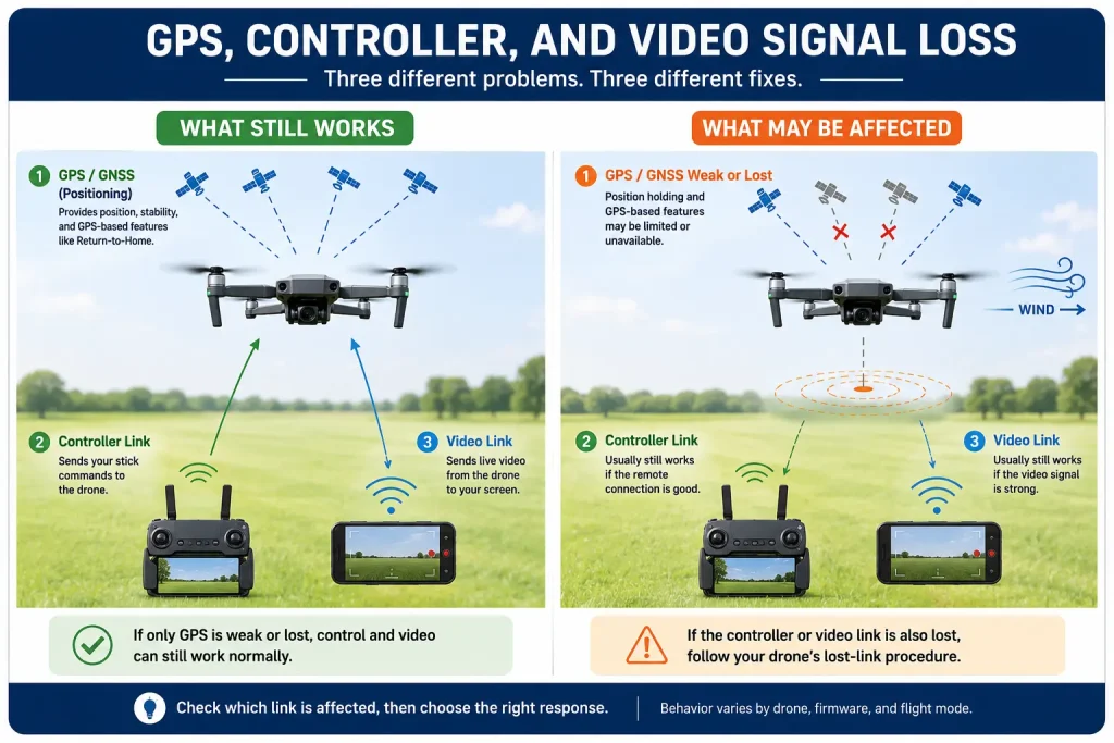
GPS Loss, Controller Signal Loss, and Video Loss Are Three Different Problems
“I lost signal” is too vague for troubleshooting. A drone can lose satellite positioning while the sticks and video still work. It can lose video while the aircraft still responds to the controller. It can lose the controller link while GPS remains healthy enough for a supported automatic response. The recovery depends on which link is actually missing.
| Signal Problem | What May Still Work | First Response |
|---|---|---|
| GPS / GNSS loss | Control and video may still work | Stop extending the route; stabilize manually; land if GPS does not recover |
| Controller link loss | GPS and supported automatic behavior may remain | Follow the exact model’s documented lost-link procedure |
| Video transmission loss | Control and GPS may still work | Keep visual orientation and return; do not continue outward |
The GPS drone range guide explains control range, video transmission distance, and visual line of sight as separate limits. That distinction matters here because a clear screen does not prove GPS health, and a GPS warning does not prove that the radio-control link is gone.
Read the Warning Before Choosing the Recovery
Use the status indicators the model actually provides. A GPS warning, disconnected-controller icon, frozen live view, compass warning, or low-battery alert can demand different actions. Do not reduce all of them to one “signal problem.” When the manual provides distinct alerts or flight modes, learn them before the first long outdoor flight.
Can You Still Control a Drone Without GPS?
GPS tells the flight controller where the aircraft is. The controller link tells the aircraft what the pilot is commanding. Those are different systems. If the GPS receiver loses a reliable position while the radio-control link remains connected, the sticks may still control roll, pitch, yaw, throttle, and supported flight modes. What changes is the amount of automatic position support available.
Think “Less Automatic Positioning,” Not “No Aircraft Control”
A beginner who expects the drone to stop itself after every stick input can be surprised when it begins to coast or drift. That does not necessarily mean the drone is flying away on its own. It can mean the pilot is now responsible for more of the horizontal correction that GPS position hold was previously doing. Keep inputs small and wait long enough to see the effect of each correction.
Do Not Start Rapidly Switching Modes
Rapid mode changes can make the aircraft harder to understand at the exact moment the pilot needs predictability. If the manual identifies a specific non-GPS mode or recovery procedure, use that procedure. Otherwise, keep the current controllable state, avoid unnecessary button presses, and prioritize a clear landing area.
Control-link check: If the drone still responds normally to small stick inputs, treat that as useful recovery margin. Do not spend that margin flying farther, climbing to chase satellites, or experimenting with automatic features.
Position Hold Can Weaken or Change When GPS Drops
GPS-assisted position hold continuously corrects horizontal movement using the aircraft’s estimated position. When that position estimate is no longer available, the aircraft may rely more heavily on inertial sensing, barometric altitude support, pilot input, or another positioning system that the model actually includes. None of those should be assumed to reproduce normal outdoor GPS hover behavior at every height or surface.
Why Does a Drone Drift When GPS Is Weak?
A light wind that was almost invisible during GPS hold can become obvious when the drone starts sliding. The correct response is not a large counter-command. Use short, measured corrections and re-center the aircraft over a safer portion of the route. Large inputs can create overshoot, especially when the pilot is watching the screen rather than the aircraft directly.
Altitude Hold and Horizontal Position Hold Are Not the Same Thing
A drone may appear to maintain roughly the same height while still drifting sideways. That can mislead a beginner into thinking all positioning is normal. Treat horizontal drift, mode changes, GPS warnings, and the aircraft’s response to released sticks as separate clues. A steady altitude does not prove that GPS position hold is still functioning.
Do Not Test the Limit Near Trees, Water, Buildings, or People
A GPS-loss event is not the time to learn how far the aircraft can drift before the pilot corrects it. Move away from immediate hazards only when the path is already clear, and choose a landing area with more space than you would normally need. The safest recovery is one that reduces the number of things the pilot must judge at once.
Optical Flow May Help at Low Altitude, but It Is Not a Replacement for GPS
Some beginner drones combine GPS with downward optical-flow positioning. When GPS becomes weak, optical flow may still provide low-altitude stabilization if the model supports that behavior and the ground is within the sensor’s usable conditions. That can make the aircraft feel steadier close to the ground, but it does not give the drone a global position or recreate GPS return-to-home.
Optical Flow Depends on the Surface Below the Drone
A downward vision system needs usable visual detail. Dark, reflective, uniform, moving, or distant surfaces can give it less information. A drone that feels stable over textured pavement may behave differently over water, glossy flooring, tall grass moving in wind, or at a height where the ground is no longer useful to the sensor.
For a deeper comparison of how the two positioning systems work, see our GPS vs optical flow guide. During a GPS-loss event, the practical point is simpler: optical flow may provide model-specific low-altitude assistance, but it does not restore GPS navigation or GPS-based RTH.
Low-altitude recovery boundary: Descending toward a clear landing area can make a supported downward-positioning system more useful, but never descend blindly into people, vegetation, wires, water, traffic, or an unknown surface just to make optical flow engage.
Will Return-to-Home Work Without GPS?
GPS-based return-to-home depends on position information. A stored home point tells the aircraft where home was recorded, but the drone also needs a usable estimate of its current position to navigate back to that point. If GPS becomes unreliable, RTH may be unavailable, delayed, limited, canceled, or handled differently depending on the aircraft and firmware.
A Stored Home Point Does Not Guarantee a GPS Return
Beginners sometimes assume that because the home point was recorded correctly at takeoff, the drone can always return later. The home coordinate is only one part of the problem. GPS navigation also needs to know where the aircraft is now. If the current position is uncertain, an automatic route to the stored point may not be possible in the normal way.
Do Not Intentionally Trigger Signal-Loss RTH During a GPS Problem
Turning off the controller or deliberately breaking the radio link does not fix weak GPS. It removes another control channel from the recovery. Keep manual control when you still have it. Likewise, do not wait for a low-battery RTH condition to make the decision for you. A positioning problem plus a battery problem is harder than either one alone.
The GPS return-to-home guide explains manual, low-battery, and control-signal-loss return behavior. In a GPS-loss event, the important boundary is simple: do not treat RTH as guaranteed until the model shows that valid GPS positioning and the required return conditions are restored.
Recover Toward Open Sky Only When the Route Is Already Clear
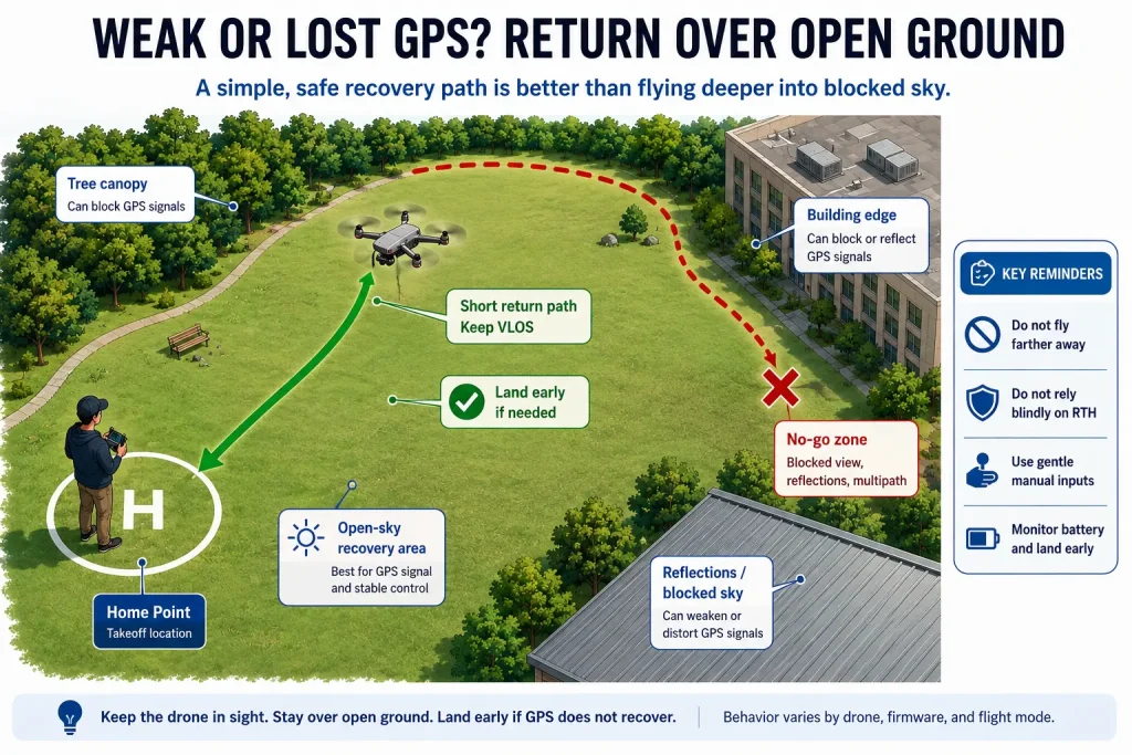
GPS usually performs best with a broad view of the sky, so a drone close to a roof, under dense tree cover, beside a tall wall, inside a structure, or in a narrow urban gap can have poorer satellite geometry than the same drone in an open field. The recovery instinct should still be conservative: move toward a known open area only when doing so does not add obstacle, battery, airspace, or visual-line-of-sight risk.
Do Not Climb Just to Chase More Satellites
A higher altitude may improve sky view in some situations, but climbing can also expose the aircraft to stronger wind, consume battery, reduce visual orientation, or place it closer to an obstacle or operating limit. If you already have a clear manual path to a safe landing area, landing is usually a simpler beginner decision than climbing in search of a better GPS indication.
Move Away From the Obstruction, Not Into a New Unknown Route
If the aircraft is beside a building edge or under a tree canopy and a short, obvious movement places it over clear open ground, that can be a reasonable recovery direction while control remains normal. Do not fly around a building, through trees, over a road, or farther from the pilot simply because the map suggests the sky may be more open there.
Pause After GPS Recovers Before Continuing Any Flight
A restored GPS icon does not mean the original mission should resume immediately. Hold over a safe area, confirm that position hold feels normal, verify the home-point and navigation status described by the manual, and decide whether there is enough battery and confidence to land normally. For a beginner, GPS recovery is a reason to end the incident safely, not a reason to immediately fly back to the farthest point.
Land When GPS Does Not Recover or the Drone Becomes Hard to Hold
A beginner does not need to keep a GPS-impaired drone airborne to find out whether the warning will disappear. If the aircraft is controllable and a safe landing area is available, landing converts an uncertain positioning problem into a simple inspection and restart decision. Continuing the flight adds wind, battery use, distance, and more opportunities for the aircraft to drift toward something.
| Condition | Continue Troubleshooting in the Air? | Safer Beginner Decision |
|---|---|---|
| GPS warning clears quickly over a known open area and hover becomes normal | Only long enough to confirm stable behavior | Return or land; do not resume a long route |
| GPS remains weak but manual control is predictable | No need to stay airborne | Fly directly to the nearest suitable landing area |
| Drone drifts faster than you can comfortably correct | No | Descend and land in the clearest reachable area |
| Battery is falling faster than expected | No | End the flight before positioning and battery problems combine |
| Video, control, or orientation also becomes uncertain | No | Use the documented recovery procedure and prioritize landing |
| No safe landing area is immediately available | Only as required to reach one | Keep movements small and choose the simplest clear route |
Abort rule: Land when any one of these becomes uncertain: manual control, aircraft orientation, GPS status, battery margin, the route to the landing area, or the safety of the landing area itself.
Why Does My Drone Keep Losing GPS Signal?
The causes matter mainly because some are environmental and can be removed, while others require the flight to stop. GPS receivers work with very weak satellite signals, so the aircraft needs a usable view of the sky and a healthy receiver/antenna system. GPS.gov lists signal blockage from buildings and trees, indoor use, and reflected signals from buildings or walls among common causes of degraded GPS positioning. Look for obvious site conditions first rather than guessing at a hidden hardware fault while the drone is still airborne.
Roofs, Indoor Areas, and Dense Tree Cover Can Block the Sky
A roof or dense canopy can block enough satellite signals to reduce positioning quality. Indoor flights are a common example: the controller may power on normally and the motors may work, yet GPS can remain weak because the aircraft does not have the open-sky view it was designed to use.
Tall Buildings and Hard Surfaces Can Distort the Positioning Environment
In narrow spaces between tall structures, satellite signals can be blocked or reflected before reaching the receiver. The result can be poorer position quality than the same aircraft has in an open field. This is one reason a GPS warning near a building should lead to a short recovery route, not a deeper flight into the same corridor.
Antenna, Firmware, or Aircraft Faults Need Ground-Level Diagnosis
If GPS remains abnormal in a clear open area after a normal restart and the model’s required setup steps, do not keep testing in flight. The cause may involve the receiver, antenna, firmware, configuration, or another aircraft fault. Use the model manual and supplier support on the ground. A generic GPS warning alone is not enough to identify a receiver, antenna, firmware, or hardware failure.
After Landing, Separate a Site-Specific GPS Drop From a Repeated Aircraft Fault
Once the drone is safely on the ground, the troubleshooting job changes. You no longer need to decide how to keep the aircraft away from an obstacle; you need to decide whether the GPS problem belonged to the location, the setup, or the aircraft. This is the right time to inspect the warning, record what happened, and repeat only low-risk checks on the ground or during a very short controlled hover.
Start by Reconstructing the Exact Moment GPS Became Weak
Write down where the aircraft was relative to roofs, tree cover, walls, vehicles, metal structures, or other obstructions. Note whether the warning appeared immediately after takeoff, only after flying beside a structure, or after the aircraft had been stable in open sky for several minutes. A single GPS drop under a roof and repeated GPS loss in an open field are very different clues.
If the controller or app preserves a warning message, flight log, satellite-status page, or screenshot, keep it. Do not rely on memory alone, especially if several alerts appeared close together. A GPS warning followed by a low-battery warning can feel like one event in the air, but the repair or support decision may depend on which alert appeared first.
Repeat the Setup in Open Sky Before Blaming the GPS Hardware
Move to a clear outdoor area that matches the model’s normal GPS-use environment. Follow the startup sequence in the manual, wait for the documented GPS-ready indication, and keep the aircraft on the ground long enough to see whether the status becomes stable. Do not invent a universal satellite-count target. The correct ready indication may be an icon, voice prompt, flight-mode label, or other model-specific signal.
If the aircraft reaches its normal GPS-ready state in open sky and remains stable during a short, close hover, the original site may have been the main factor. That does not prove the issue is solved permanently, but it gives you a safer working hypothesis than immediately recalibrating every sensor or assuming the receiver is defective.
Stop Testing When the Same GPS Fault Repeats in a Clear Open Area
A repeated GPS warning in an unobstructed area deserves a ground-level investigation. Do not keep launching farther or higher to see whether the problem disappears. Check the model manual, firmware requirements, antenna or shell damage that can be inspected safely, and any supplier troubleshooting steps. If the aircraft recently suffered an impact, repair, water exposure, or unusual warning, include that history when asking for support.
| Post-Landing Observation | What It Suggests | Next Step |
|---|---|---|
| GPS was weak only under trees or beside a structure | Site obstruction may be the main factor | Use a more open launch and route; confirm normal GPS before takeoff |
| GPS becomes normal in open sky and short hover is stable | The aircraft may be functioning normally in a better environment | Keep the next flight short and avoid the original GPS-poor area |
| GPS repeatedly fails in clear open sky | Model, antenna, firmware, setup, or hardware issue may need diagnosis | Stop normal flying and use the manual or supplier support |
| GPS warning appears together with another sensor or battery warning | The event may not be a GPS-only problem | Preserve logs/screenshots and troubleshoot the complete alert sequence |
| Behavior changed after impact, moisture, repair, or firmware update | A recent change may be relevant | Do not assume a site-only cause; document the change for support |
Do Not Use Recalibration as a Generic Cure for Every GPS Warning
Calibration procedures are model-specific and are usually intended for particular sensors or conditions. A GPS warning caused by blocked sky does not automatically mean the compass, IMU, or another sensor needs calibration. Recalibrate only when the manual or a documented warning calls for it. Unnecessary calibration adds another variable when the goal is to isolate the original problem.
Post-flight decision: One GPS drop in a clearly obstructed location can point to the environment. Repeated GPS loss in open sky should move the problem out of the air and into model-specific troubleshooting, documentation, and supplier support.
What RCDronego Specs Can—and Cannot—Tell You About GPS Loss
The provided RCDronego data confirms GPS and RTH for XT606, GPS plus optical flow for GT6, and GPS plus optical flow for XT808. Those specifications establish that the positioning features exist; they do not establish how each aircraft changes mode when GPS becomes weak, whether optical flow remains active at a particular height, what exact warning appears, whether RTH is inhibited, or how quickly GPS is reacquired.
The supplied specifications also place S-X1 and AE20 Max in the GPS product line, but the provided per-model data does not document their exact GPS-loss transition or recovery behavior. Do not invent that behavior from the category name, screen remote, camera system, listed range, or price.
Buyers comparing confirmed everyday GPS features can use the GPS drone guide for beginners. Until the exact model manual, firmware notes, or controlled evidence confirms the fallback behavior, use the listed specifications only to verify which positioning features the drone includes—not how it will behave after GPS is lost.
Model-specific caution: Do not assume that a drone automatically switches to ATTI mode, that optical flow always takes over, that RTH is disabled after a fixed delay, or that GPS will recover within a predictable number of seconds. Those behaviors depend on the exact aircraft, firmware, and documented flight logic.
Beginner GPS-Loss Emergency Checklist
The Moment the GPS Warning Appears
- Stop flying farther, faster, or higher.
- Confirm that the controller still produces predictable stick response.
- Keep the aircraft within direct visual awareness and identify its direction of movement.
- Check whether the warning is GPS-specific rather than a video, control-link, compass, or battery alert.
- Avoid pressing RTH until the model’s GPS and return status is understood.
While the Drone Is Still Controllable
- Use short, measured stick inputs instead of large corrections.
- Keep the aircraft away from trees, wires, buildings, water, roads, and people.
- Move toward a known open landing area only when the route is already clear.
- Do not climb simply to improve satellite count.
- Watch the battery trend because manual correction and extra recovery time consume reserve.
If GPS Returns
- Hold over a safe area and confirm that horizontal position hold feels normal again.
- Verify the home-point and navigation indications specified by the model manual.
- Do not immediately resume the original long route.
- Return or land while battery and visual margin remain comfortable.
If GPS Does Not Return
- Keep manual control and fly the shortest clear route to a safe landing area.
- Do not intentionally trigger control-signal loss or low-battery RTH.
- Land before the drone becomes difficult to hold or the battery reserve becomes small.
- After landing, inspect the aircraft and use the model-specific manual or supplier procedure before another flight.
Beginner rule: A GPS-loss recovery is successful when the drone reaches the ground safely. Reacquiring satellites in the air is optional; preserving control, battery, and a clear landing path is not.
Frequently Asked Questions About Drone GPS Signal Loss
Usually, GPS loss by itself does not mean the motors stop or the drone immediately falls. On a controllable aircraft, the larger change may be reduced horizontal position hold or a different supported flight mode. Exact behavior varies by model, so use the manual and land if the aircraft becomes difficult to hold.
You may still have manual control if the controller link remains connected. GPS positioning and the radio-control link are separate systems. Use small inputs, stop extending the route, and recover toward a safe landing area.
Do not assume it will. GPS-based RTH needs usable position information, and behavior during weak or invalid GPS varies by model and firmware. Keep manual control when available and land rather than intentionally creating another failure to test RTH.
It may provide low-altitude stabilization on a compatible model under suitable surface and height conditions, but this is model-specific. Optical flow does not provide the global position information required to replace GPS navigation or GPS-based RTH.
Not automatically. Climbing can increase wind exposure, battery use, and obstacle or operating-limit risk. If you already have a clear route to a safe landing area, landing is usually a simpler beginner response than climbing to chase satellites.
GPS position hold normally corrects horizontal movement. When that support becomes weak or unavailable, wind and residual motion can become more obvious and the pilot may need more manual correction. Drift alone does not prove GPS loss, so confirm the actual positioning status on the model.
The Bottom Line: When a Drone Loses GPS, Keep Control and Simplify the Flight
What happens if a drone loses GPS signal? The drone may continue responding to the controller while GPS-dependent position hold and navigation become less reliable. Do not treat that as an invitation to keep flying. Stop extending the route, make small manual corrections, separate GPS loss from controller or video loss, avoid relying on RTH until valid positioning is restored, and land if GPS does not recover or the aircraft becomes hard to hold. The safest beginner recovery is not the one that proves the drone can regain GPS in the air; it is the one that gets the aircraft onto clear ground while control, battery, and orientation are still comfortable.