
How to Fly a Drone Over Water Safely
Bywpdev
Beginner Water-Flight Decision
Learning how to fly a drone over water safely starts with a dry launch area, a correctly recorded home point, and a short return route. Confirm that the location and airspace allow the flight; test GPS, controls, live view, and manually activated return-to-home over land; then cross the shoreline only while substantial battery and wind margin remain. Do not depend on obstacle avoidance, optical flow, maximum transmission distance, or waterproofing that has not been verified for the exact model.
- Choose a dry launch and landing area with a clear view of the route.
- Check airspace, shoreline access, local restrictions, wind, visibility, and precipitation.
- Confirm GPS and the recorded home point before crossing the shoreline.
- Test manually activated RTH over dry ground only when the model manual provides a safe procedure; do not intentionally trigger signal-loss or low-battery RTH.
- Keep the first route short, reversible, and within visual line of sight.
- Return while substantial battery reserve and a dry landing option remain.
Crossing a shoreline removes many emergency landing choices. Over land, an unexpected battery warning may leave several places to descend; over water, the home point or a planned dry alternate may be the only practical recovery option.
Reflections, glare, waves, haze, and a bright horizon can also make altitude, direction, and distance harder to judge. A stable live view may hide distance, while a tailwind can make the outbound leg look easier than the return.
This guide follows the actual order of a beginner flight: decide whether the site is suitable, prepare a dry home point, confirm GPS and RTH behavior over land, cross the shoreline only after those checks, preserve battery and wind margin, and abort early when any part of the plan becomes uncertain.
How to Fly a Drone Over Water Safely Starts Before the Drone Powers On
The most important water-flight decisions are easier to make before the aircraft is in the air. A usable shoreline needs more than a scenic view. It needs a legal takeoff location, a dry and level home point, enough space to launch and land, a clear line of sight, a predictable return path, and a route that does not force the drone behind trees, cliffs, buildings, boats, or terrain.
Confirm Airspace and Shoreline Access Separately
Airspace permission and land-use permission are not the same decision. A location may appear open on a map while a park, marina, beach, dam, wildlife area, or private shoreline restricts drone takeoff and landing. In the United States, recreational flyers should check current FAA airspace information and also confirm the rules of the property owner or managing authority.
The FAA’s Where Can I Fly? resources explain airspace restrictions and B4UFLY services. They do not grant permission to use private property or override state, local, tribal, park, wildlife, or site-specific restrictions. Rules differ outside the United States, so verify the requirements that apply to the actual location and purpose of the flight.
Choose a Dry Home Point With Space Around It
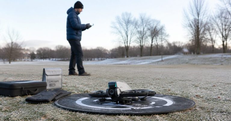
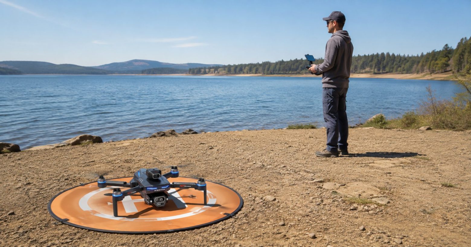
Place the launch pad on dry, stable ground away from spray, wet sand, mud, loose gravel, reeds, waves, vehicle traffic, and people. The landing area should remain usable even if the wind shifts or the shoreline becomes busier. Avoid a narrow dock, moving boat, sloped rock, floating platform, or patch of sand that a wave can reach.
Check the home point from the expected return direction. Trees, power lines, roofs, bridge structures, masts, and cliff edges can turn a direct return into a collision risk.
Plan an Alternate Dry Landing Area Before Takeoff
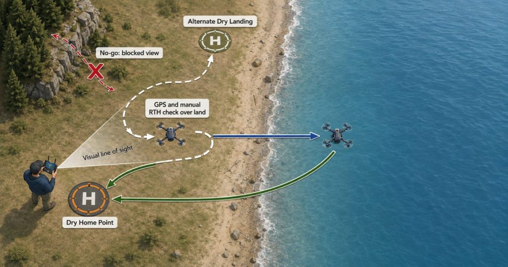
Identify at least one reachable dry landing area that is closer than the home point for part of the route. This may be another open section of shoreline, a clear field, or a stable section of dry ground. The alternate should not require flying over people, traffic, trees, structures, or restricted property to reach it.
The alternate does not justify a longer flight; it gives the pilot a dry decision point if the home area becomes obstructed or the battery no longer supports a comfortable return.
No-go boundary: Do not launch when the only landing option is water, a moving boat, wet rock, a narrow dock, restricted property, or a route that cannot remain within visual line of sight.
Record the GPS Home Point on Dry Ground and Verify the Return Path
A GPS drone can record a home point and use it for supported return-to-home functions, but the feature is useful only when the recorded point is correct and the path back is clear. Do not assume that powering on near the shoreline automatically creates a reliable home point.
Wait for the Model’s Confirmed GPS and Home-Point Indication
Follow the model manual and wait for the aircraft and controller to indicate that GPS positioning is ready and the home point has been recorded. The exact number of satellites, screen icon, voice message, light pattern, or confirmation method varies by model. Do not invent a universal satellite count or take off because the live camera view already appears.
If the home point appears in the wrong location, changes unexpectedly, or is not clearly confirmed, power down and restart according to the manual or move to a more open site. Water is not the place to continue a setup that the pilot does not understand.
Set a Return Altitude That Clears Real Obstacles Without Wasting Battery
Where the model allows a return altitude to be configured, choose a height that clears nearby trees, shoreline structures, boats with tall masts, poles, and terrain while remaining appropriate for the airspace and route. An unnecessarily high climb can consume battery, while a return altitude that is too low can place the aircraft into obstacles.
Do not copy a number from another pilot or another location. The correct setting depends on the actual surroundings and the aircraft’s supported behavior. A cliff, marina, bridge, or tree line can require a different return plan from an open lake shore.
Remember That Return-to-Home Targets the Recorded Point
If the pilot walks along the shoreline after takeoff, the recorded home point may remain where the drone originally launched unless the model supports and correctly performs a home-point update. The aircraft does not automatically know that the pilot moved to a different dry area.
The full GPS return-to-home guide explains manual, low-battery, and signal-loss return behavior. For this water-flight workflow, the key decision is simple: confirm the recorded point, understand the model’s supported triggers, and keep enough battery to return manually before automation becomes necessary.
Test GPS, Controls, Live View, and Manually Activated RTH Over Land First
Do not cross the shoreline immediately after takeoff. Use the first part of the flight to confirm that the drone behaves normally over a dry area where an immediate landing is possible. This is not a complete test program; it is a short decision check before the risk of an unusable landing surface begins.
- Lift to a low, clear hover. Observe position hold, motor sound, battery trend, warning messages, and control response.
- Move a short distance in each planned control direction. Confirm that the drone responds to deliberate stick input without unexpected drift or delay.
- Check the live view and screen remote. Confirm that the image, telemetry, battery status, and GPS indication remain readable.
- Fly a short out-and-back route over land. Verify that the drone can return smoothly while the pilot still has a clear landing area.
- Test manually activated RTH over dry ground only when the manual provides a safe procedure. Remain ready to cancel or take control, and do not intentionally trigger signal-loss or low-battery RTH.
- Land if any behavior is unclear. Do not cross the shoreline to “see whether it improves.”
A Successful Hover Does Not Prove the Full Water Route
The drone may hold position well near the ground and still face different wind, signal, glare, altitude, and battery conditions farther from shore. Passing the land check confirms only the behavior observed at that moment. It does not validate maximum range, waterproofing, obstacle detection, or a long return.
Keep the Drone Within Visual Line of Sight
In the U.S., recreational flyers are required to keep the drone within visual line of sight, or use a co-located visual observer in direct communication with the pilot. The FAA’s current recreational-flyer rules also cover airspace, altitude, registration, Remote ID, and TRUST requirements. Those rules do not determine whether a particular shoreline, battery, wind condition, or model is safe for a water route.
Water can make a small aircraft harder to see because the background is uniform and reflective. Do not use the screen image as a substitute for direct visual awareness. Turn back before orientation becomes uncertain.
Cross-shoreline rule: The first water route should begin only after a normal low hover, a short manual return, a readable live-view check, and—when the model manual provides a safe procedure—a manually activated RTH check over dry ground.
Fly the First Water Route Short, Reversible, and Into the Wind When Practical
A beginner’s first route over water should not follow the maximum control range, transmission range, or battery claim printed on a product page. The useful route is the one the pilot can see, reverse, and complete with a large battery reserve after accounting for wind and a dry landing.
Use a Simple Out-and-Back Line Instead of a Long Shoreline Tour
Begin with a short straight path that crosses the shoreline, pauses briefly, and returns. Keep the drone close enough that the pilot can judge its orientation without depending on the screen. A straight route reduces the number of turns and makes it easier to compare outbound and return behavior.
Avoid long orbits around boats, islands, cliffs, waterfalls, marinas, or people. Complex paths add distance, visual obstructions, and pressure to finish the shot after conditions change.
Fly Out Into the Wind and Return With It When Practical
A conservative route often sends the drone into the wind first and returns with a tailwind, provided the airspace, shoreline, route, and model allow it. The aircraft uses the harder direction while the battery is fullest and receives assistance on the way back. Flying away with a tailwind can create a deceptively easy outbound leg followed by a slower, higher-power return.
Crosswinds, turbulence near cliffs, changing coastal wind, and sheltered launch areas complicate this rule. Do not assume the wind direction and strength over the water match what you feel behind trees or buildings on shore. Use the beginner drone wind guide for the full sustained-wind, gust, altitude, and return-margin decision.
Do Not Descend Close to the Water for the First Shot
A low pass reduces the time available to correct altitude, signal, positioning, or control errors. Waves, spray, reflections, birds, reeds, masts, and fishing lines can enter the route quickly.
Maintain conservative clearance above the water and nearby hazards so that a brief descent or positioning error does not result in contact with the surface. The appropriate clearance depends on the model, waves, spray, route, obstacles, airspace, and visibility; there is no universal over-water altitude.
| First-Route Choice | Why It Helps Over Water | What to Avoid |
|---|---|---|
| Short straight out-and-back route | Easy to reverse and compare outbound with return behavior | Long shoreline tour or orbit |
| Harder wind direction first when practical | Uses the fullest battery for the more demanding leg | Fast tailwind departure followed by headwind return |
| Moderate height above water | Leaves correction time and clearance from spray or waves | Immediate low pass close to the surface |
| Open route within visual line of sight | Reduces signal masking and orientation loss | Flying behind cliffs, trees, bridges, or boats |
| One simple shot | Allows attention to remain on battery, wind, and position | Multiple automated moves during the first water flight |
Keep More Drone Battery Reserve Over Water Than Over an Open Field
Over water, battery reserve is not simply unused flight time. It is the power needed to reverse the route, correct for wind, climb if an obstacle enters the path, recover from a delayed turn, reach a dry landing area, descend, and handle an unexpected change at the home point.
Listed Flight Time Is Not the Water-Route Budget
Based on the supplied RCDronego specifications, XT606 and GT6 are listed at approximately 25 minutes, while AE20 Max is listed at approximately 22 minutes. Those figures are not guaranteed water-flight results. Wind, temperature, battery age, payload, climbing, camera use, signal conditions, flight mode, and pilot input can change actual endurance.
A listed 25-minute flight time does not justify planning 20 minutes over water and reserving the final five for return and landing. The correct reserve cannot be a universal percentage because model behavior, battery condition, route, wind, and warning logic differ. Return based on the actual trend and the remaining recovery choices, not a copied number.
Watch the Rate of Battery Loss, Not Only the Displayed Percentage
A battery that falls faster than expected, produces an early warning, or loses more power during the return direction is signaling that the route should end. A stable percentage while hovering near shore does not guarantee the same trend during a climb or headwind return.
If the battery reading rebounds after reducing throttle or landing, do not treat that change as energy restored to the pack. End the flight and inspect the battery rather than using the recovered display as a reason to cross the shoreline again.
Maximum Range and Battery-Supported Range Are Different
Control distance and transmission distance describe communication capabilities under stated conditions. They do not guarantee enough battery to fly out, record video, turn around, fight wind, return, and land. The GPS drone range guide explains why the usable route is normally shorter than a listed distance claim.
Battery boundary: Begin the return while the drone still has enough reserve to reach a dry alternate landing area. Low-battery RTH is a backstop on supported models, not the normal plan for crossing water.
Water Reflections Can Limit Optical Flow and Obstacle-Avoidance Assistance
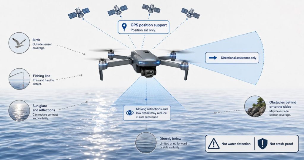
Over reflective or moving water, a downward vision system may receive less usable surface detail than it receives over textured dry ground. GPS may still support outdoor positioning on a compatible aircraft, but it does not measure the water surface or create a safe landing option. Obstacle assistance remains directional and condition-dependent; none of these functions makes water a safe landing surface.
Optical Flow May Have Less Reliable Surface Detail Over Water
Water can present moving waves, repeated patterns, glare, reflections, transparent areas, and low contrast. Depending on the sensor, altitude, light, surface, and aircraft design, the downward system may have less useful visual information than it has over textured dry ground.
Do not use optical-flow positioning as permission to hover close to the surface. Maintain manual awareness of altitude and route, and follow the model manual for any surfaces or lighting conditions that the vision system does not support.
Obstacle Avoidance Is Not a Water, Wire, or Bird Detector
Obstacle assistance may miss fishing line, wires, reflections, low-contrast objects, moving birds, fast approaches, side hazards, or anything outside the sensor’s coverage. Forward sensing does not imply equivalent protection below, above, behind, or to the side.
The supplied GT6 data describes an optional obstacle head that can stop the aircraft when it detects an obstacle. It does not establish all-direction coverage, water-surface, wire, or bird detection, or crash prevention. Confirm that the selected package includes it.
Use the drone obstacle-avoidance guide for the complete sensor boundary. For a water flight, the practical rule is to build a clear route that does not require the sensor to save the aircraft.
A Gimbal or EIS Stabilizes Video, Not the Aircraft’s Recovery Margin
A gimbal or EIS can make footage look calm while the aircraft is correcting for wind or position. Judge the flight from the drone, telemetry, route, battery trend, and return speed—not the smoothness of the video.
| Drone Feature | What It Can Support | What It Does Not Guarantee Over Water |
|---|---|---|
| GPS positioning | Outdoor position estimate and supported RTH functions | Accurate home point, safe route, obstacle clearance, or enough battery |
| Optical flow | Low-altitude position assistance over suitable visible texture | Reliable hold over glare, waves, reflections, or low-detail water |
| Obstacle assistance | Detection of some supported objects in covered directions | Crash-proof flight, water detection, fishing-line detection, or all-direction coverage |
| Screen remote | Live view and telemetry without relying only on a phone | Visual line of sight, reliable signal at maximum range, or safe orientation |
| Gimbal or EIS | Smoother recorded footage | Stable aircraft position, wind resistance, or battery reserve |
Plan Different Drone Routes for Lakes, Rivers, Reservoirs, and Coastlines
“Over water” is not one environment. A calm inland lake, a narrow river, a managed reservoir, and an exposed coast create different route, wind, access, signal, wildlife, and emergency-landing decisions.
Lake Routes: Watch Reflections, Boats, and Distant Shorelines
A lake can look calm and open, which encourages beginners to fly farther than they can judge visually. Reflections may hide orientation, and a distant opposite shore can create the impression of an available landing point even when access is restricted or the battery cannot reach it.
Keep the route near the launch shoreline, avoid active swimmers and boats, and do not use an island or far shore as the first target. Where shoreline geometry and access allow, an oblique or shoreline-parallel route may keep more dry landing options visible than a route toward open water. Confirm that it does not cross people, boats, restricted property, trees, or structures.
River Routes: Avoid Following the Channel Behind Trees or Bends
Rivers can lead the drone into a winding corridor where trees, banks, bridges, cliffs, and terrain block the direct view or signal path. Current direction does not matter to an aircraft in the air, but the river’s shape can tempt the pilot to follow it beyond visual line of sight.
Choose a short section with open banks, no bridge traffic, no fishing lines, and a clear straight return. Do not descend into a low channel where the surrounding banks and vegetation reduce visibility and GPS or communication conditions.
Reservoir and Dam Routes: Confirm Site Restrictions Before Setup
Reservoirs and dams may include critical infrastructure, controlled access, posted restrictions, wildlife areas, power equipment, and local rules that are not obvious from the water itself. Confirm both airspace and the managing authority’s takeoff and landing policy before bringing the drone to the launch area.
Do not fly close to dam structures, spillways, power lines, workers, security areas, or vessels. Choose a different location when the desired image requires entering a restricted or operational area.
Coastal Routes: Treat Wind, Spray, Birds, and Cliffs as Separate Hazards
Coastal wind can change with exposure, terrain, and time. Salt spray and mist can reach an aircraft even when it is not raining, and cliffs can create turbulence or block the return path. Seabirds may approach or defend nesting areas.
Launch well back from breaking waves, keep the drone away from birds and cliffs, and avoid a route that depends on flying around a headland. Do not assume any RCDronego model is protected against saltwater, spray, rain, or immersion; the supplied specifications do not provide a verified water-resistance rating.
Abort the Water Flight When GPS, Video, Battery, or Control Behavior Changes
The safest water-flight decision is often made before a warning becomes critical. A pilot who waits for complete signal loss, a final battery alert, or obvious uncontrolled movement may have already used the reserve needed to reach dry ground.
| Observed Change | Possible Water-Flight Meaning | Beginner Response |
|---|---|---|
| GPS status changes or position hold becomes less predictable | The aircraft may no longer maintain the expected route or home-point behavior | Move toward dry ground and land while manual control remains clear |
| Live view freezes, breaks up, or becomes delayed | Transmission margin or interference may be changing | Stop moving farther away, face the route visually, and return |
| Battery falls faster than expected | Wind, battery condition, route, temperature, or power demand is consuming the reserve | Return immediately and use the nearest safe dry landing area |
| Return speed is lower than outbound speed | The aircraft may be fighting a headwind or stronger exposed wind | Reduce delay, avoid climbing unless necessary, and return early |
| The drone drifts, yaws, or changes altitude unexpectedly | Wind, positioning, sensor, or control margin may have changed | Leave the water route and land rather than continuing the shot |
| Birds approach or begin circling | The route may be entering active wildlife space | Leave the area smoothly without chasing or approaching the birds |
| Spray, mist, rain, or fog reaches the route | Visibility and unverified moisture exposure are increasing | Return to dry ground and power down |
Do Not Keep Flying to Reconnect a Weak Video Signal
When the live view becomes unstable, stop increasing distance, keep the aircraft in sight, and begin returning along the clearest route. Do not climb only to recover the video signal. Any altitude change must remain inside the applicable airspace limits, preserve battery reserve, and follow the model manual and actual obstacle conditions.
Use Manual Return Before Supported Automatic Recovery Becomes Necessary
While visual reference, control, and battery reserve remain clear, begin a deliberate manual return instead of waiting for signal-loss or low-battery RTH. Automatic behavior varies by model, firmware, GPS status, battery state, altitude setting, and trigger.
If supported RTH activates, monitor the aircraft and follow the manual. Do not cancel it reflexively when the trigger is unknown, and do not assume a direct return will avoid every boat, mast, cable, tree, or structure.
Land on Reachable Dry Ground Instead of Finishing the Shot
When battery or control margin changes, the priority is a reachable dry landing area—not finishing an orbit, revealing the opposite shore, or returning to the exact takeoff mark. A clear alternate area closer to the drone can be safer than forcing the aircraft through wind or around an obstacle to reach the original home point.
If the Drone Enters the Water, Do Not Power It Back On
Do not risk personal safety to recover a drone from deep, fast-moving, cold, contaminated, or hazardous water. If recovery is safe, keep the aircraft powered off and do not reconnect or charge the battery. Separate it only when the instructions permit. Isolate a wet, swollen, damaged, hot, or saltwater-exposed battery from combustible materials and contact the supplier or an appropriate disposal service.
Immediate-return rule: End the water route when any one of these becomes uncertain: visual orientation, GPS status, control response, live-view reliability, battery trend, wind margin, dry landing access, or the legality of continuing.
RCDronego Features Do Not Prove Water Resistance or Water-Recovery Capability
RCDronego evidence boundary: GPS, RTH, optical flow, a screen remote, EIS, a gimbal, listed range, listed flight time, and obstacle assistance do not prove that a drone is waterproof or safe to land on water. The supplied specifications do not provide a verified rain, spray, saltwater, immersion, flotation, or water-landing rating for XT606, GT6, S-X1, AE20 Max, or XT808.
Buyers can compare confirmed camera, positioning, screen, range, weight, and listed flight-time differences in the GPS drone guide for beginners. Any model-specific moisture, sensor-over-water, or recovery claim still requires current documentation or controlled evidence for that exact aircraft.
Beginner Checklist Before Flying a Drone Over Water
Before Takeoff
- Read the current aircraft, battery, GPS, RTH, controller, and sensor instructions.
- Confirm airspace, land-use permission, wind, visibility, precipitation, and site access.
- Use a healthy charged battery and controller; reject wet, damaged, swollen, or fault-reporting equipment.
- Select a dry home point, a reachable dry alternate, and a visible route clear of people, boats, wildlife, wires, and structures.
Before Crossing the Shoreline
- Inspect propellers, motors, camera, battery latch, contacts, antennas, and sensors.
- Confirm GPS readiness, the recorded home point, and a return altitude suited to actual obstacles.
- Complete a low hover and short manual out-and-back route over dry ground.
- Test manually activated RTH only when the manual provides a safe dry-ground procedure; never trigger signal-loss or low-battery RTH intentionally.
Over the Water
- Keep the route short, visible, reversible, and close to a dry landing option.
- Maintain conservative clearance from water, spray, birds, reeds, boats, and fishing lines.
- Watch battery-loss rate, return speed, GPS status, live view, wind, and aircraft behavior.
- Return immediately when any margin changes; do not rely on optical flow or obstacle avoidance to interpret the surface.
After Landing
- Power down on dry ground and inspect the drone and battery for moisture or damage.
- Do not relaunch after an unexplained warning, rapid battery loss, or abnormal control behavior.
- If the aircraft entered the water, do not power it back on or charge the battery; follow supplier recovery and disposal instructions.
- Record the route, conditions, warnings, and landing reserve before extending a future flight.
Beginner decision: Skip the flight when the site lacks a legal dry launch point, the route cannot remain visible, wind makes the return uncertain, moisture is present, GPS or RTH behavior is unclear, or the battery cannot preserve a large dry-landing reserve.
Frequently Asked Questions About Flying a Drone Over Water
A beginner can fly over water only after confirming a legal dry launch area, GPS and home-point status, predictable controls, wind margin, visual line of sight, and enough battery for an early dry-ground return. Test manually activated RTH over dry ground only when the manual provides a safe procedure.
Do not change a positioning setting unless the exact model manual instructs you to. Water may provide less usable visual texture for some downward systems. Maintain altitude awareness, stay clear of the surface, and do not treat optical flow as the primary safety system.
No. RTH cannot restore battery power, guarantee GPS accuracy, or detect every obstacle or headwind. Confirm the home point and return altitude, test only manually activated RTH over dry ground when the manual permits it, and return manually while substantial reserve remains.
There is no universal return percentage. Use distance, wind, battery-loss rate, landing options, and model behavior to decide. Begin the return while enough reserve remains to reach dry ground without depending on the normal low-battery warning.
Do not assume it can. Sensors may miss reflections, low-contrast surfaces, fishing lines, birds, side hazards, or objects outside their coverage. Obstacle avoidance is an assist, not a water-surface detector or crash guarantee.
The supplied specifications do not provide a verified waterproof, rain, spray, saltwater, immersion, or water-landing rating for XT606, GT6, S-X1, AE20 Max, or XT808. Use a model around moisture only when its exact current documentation explicitly permits it.
The Bottom Line
Learning how to fly a drone over water safely means accepting that the aircraft has fewer recovery options after it crosses the shoreline. Start from legal, dry, open ground; confirm GPS and the recorded home point; test controls, live view, and supported RTH behavior over land; fly a short visible route; preserve more battery than the shot appears to need; and return as soon as wind, GPS, signal, battery, visibility, wildlife, or landing access changes. GPS, optical flow, obstacle assistance, a screen remote, a gimbal, and a long listed range can support the flight, but none of them makes the drone waterproof or guarantees a safe return.